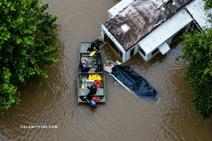

When Relentless Rain Turns Streets Into Rivers
Tropical Storm Arthur left a dangerous flood threat across several Gulf states. Its remnants pushed severe weather from Thursday night into Friday morning. At least one death was reported amid widespread storm related damage. Several cities faced serious impacts as water rose across roads.
Emergency officials warned that the danger had not passed for residents. Forecasts called for more heavy rain across the region this weekend. Louisiana responded with a statewide emergency declaration from Governor Jeff Landry. The order cited widespread rainfall, severe storms, and major flooding concerns.
Reports described tornadoes, damaged homes, damaged businesses, and fallen trees. Some areas received more than a foot of rain within one day. That volume left neighborhoods exposed to fast water and sudden isolation. The storm created dangerous conditions across communities already under pressure.
Infrastructure strain became clear as water overwhelmed streets and low areas. Emergency teams tracked flooded routes, stranded vehicles, and threatened properties. Across the Gulf Coast, saturated ground made each forecast more alarming.
Emergency Declarations Meet Widespread Damage
Louisiana’s emergency declaration turned a weather crisis into a statewide response. The order gave officials broader authority as storm damage spread across parishes. Reports of tornadoes added urgency to the state’s protective actions. Public safety concerns grew as conditions changed faster than normal response plans.
State officials described communities under pressure from several hazards at once. Heavy rainfall left some places above one foot within twenty four hours. That amount placed homes, shops, and local routes under immediate threat. Damage reports also included trees down across affected neighborhoods.
The declaration reflected more than routine caution after a severe weather event. It acknowledged that public infrastructure could face repeated strain under extreme rain. Homes and businesses became vulnerable as water entered structures across multiple areas.
Official reports pointed to a storm environment capable of rapid deterioration. Crews had to address damage while new hazards remained possible. That combination made recovery work harder for residents and responders.
Local impacts reached beyond property damage and temporary service disruption. Downed trees blocked access and created risks for cleanup crews. Businesses faced interruptions as floodwater threatened interiors, equipment, and supplies. Families also faced uncertainty about safe travel and property protection.
The statewide order placed the situation within a broader emergency framework. It signaled that local damage had reached a serious operational threshold. For many communities, the storm left danger scattered across familiar places.
Communities Face Rescue Calls and Rising Waters
Flash flood emergencies unfolded across communities after rainfall reached extreme levels. Seminary and Sanford faced serious inundation as water entered structures. Residents watched conditions deteriorate rapidly as floodwater crossed developed areas. Emergency situations emerged where normal drainage systems could not cope.
Water rescue operations took place after travel routes became unsafe. Numerous vehicles remained trapped after floodwater covered surrounding roadways. Responders worked through hazardous conditions to reach affected motorists.
Plaucheville and Moreauville experienced some of the storm’s harshest effects. Rainfall totals exceeded twenty inches across portions of those communities. More than one hundred residences suffered flooding according to weather officials. Entire neighborhoods faced extensive disruption as water spread across properties.
Scenes from affected areas showed automobiles carried by strong currents. Floodwater transformed familiar streets into channels capable of moving vehicles. Such images highlighted the force that accumulated runoff could generate.
Dallas faced a separate but significant flood emergency during the event. Rainfall rates reached two inches per hour in affected locations. Weather authorities reported at least four inches had already fallen. Multiple downtown roads became impassable, particularly beneath several overpasses.
Dam Concerns Add Another Layer of Uncertainty
Anchor Lake Dam became a focus as officials watched conditions closely. The site sits near Carriere in southern Mississippi. State crews arrived to assess risk and track structural performance. Authorities said the dam had not breached during their review.
About thirty homes faced evacuation as a precaution near the site. Officials acted before a confirmed failure, due to possible downstream danger. The move reflected caution as rainfall left little storage capacity. Residents later received permission to return after the order lifted.
Mississippi officials said water passed through primary and auxiliary spillways. That function suggested the system still worked as designed. Yet limited remaining capacity kept concerns high.
The Mississippi Department of Environmental Quality found erosion near the dam. Recent heavy rainfall caused those vulnerable areas around the structure. Despite that concern, officials expressed confidence in structural integrity. Residents were still told to monitor alerts closely.
Weather authorities first reported failure based on local emergency information. A later update said the dam was under possible failure watch. The change showed how fast assessments could shift during crises. Additional rainfall could still overwhelm spillways and threaten stability.
A Region Braces for More Rain and Dangerous Heat
Forecast models showed little relief for Gulf Coast communities. Weather agencies maintained elevated concern across multiple southern states. Additional rounds of rainfall remained possible through the weekend. That outlook increased concern for areas already vulnerable to runoff.
A flood watch stretched from eastern Louisiana into central Georgia. Meteorologists also highlighted continued risk across Alabama and Florida’s Panhandle. Rainfall rates could reach two to three inches per hour. Such intensity can quickly overwhelm drainage capacity during repeated storms.
Ground conditions created another challenge for emergency planners and forecasters. Soil saturation reduced the landscape’s ability to absorb moisture. Even modest rainfall could trigger rapid water accumulation afterward. That reality increased the likelihood of renewed flash flooding.
Weather officials designated a level three flash flood risk Friday. Parts of the central Gulf Coast remained under heightened scrutiny. Earlier outlooks even reached the highest category available from forecasters. Historical data links those designations with severe losses and fatalities.
Atmospheric moisture also contributed to dangerous heat across the region. Heat indices climbed above one hundred ten degrees in places. New Orleans, Houston, and Corpus Christi faced particularly oppressive conditions. The combination of heat and moisture underscored the event’s severity.

CALAMITY360.com delivers global news and safety insights on earthquakes, tsunamis, volcanic eruptions, floods, wildfires, storms, and tornadoes. It provides timely updates, expert tips, and disaster-readiness information to foster awareness, preparedness, and resilience across communities worldwide.