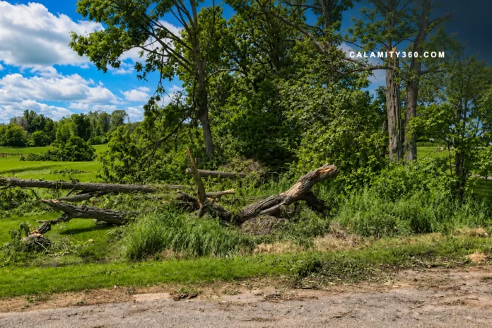

When a Summer Storm Leaves Its Mark on the Landscape
The National Weather Service confirmed a tornado touched down in Yates County. Survey teams identified the event after examinations of storm damage. The tornado occurred at approximately 10:55 a.m. EDT on Thursday. Officials later assigned the storm an EF1 classification.
Preliminary findings placed the tornado within the lower end of stronger categories. Meteorologists estimated peak winds reached approximately ninety miles per hour. Damage evidence provided the foundation for that initial assessment. Additional review could still refine details from the survey.
The confirmed tornado emerged during a period of active weather. Powerful storms affected multiple areas across New York on Thursday. Communities experienced damaging winds, heavy rainfall, and power disruptions. Conditions highlighted the reach of the broader storm system.
Parts of the Finger Lakes felt impacts from the severe outbreak. Central New York also faced hazardous weather during the event. Areas within the Southern Tier reported consequences from the storms. The tornado became one notable feature within a wider weather episode.
A Narrow Path Carries Powerful Winds Across Yates County
Survey teams traced a distinct corridor where the tornado crossed terrain. Their assessment measured a track extending approximately 1.2 miles. Evidence showed a concentrated area where damage aligned consistently. That pattern helped define the storm’s route through affected sections.
The tornado also displayed a relatively narrow physical footprint. Investigators measured a maximum width near one hundred fifty yards. Conditions changed sharply inside that corridor compared with nearby areas. Such boundaries offered valuable clues during the damage assessment process.
Wind estimates relied on physical evidence left after the storm. Analysts calculated peak intensity near ninety miles per hour. That estimate reflected the strength necessary to create observed impacts.
Field crews examined numerous locations to establish the tornado’s characteristics. They compared damage patterns across vegetation, structures, and exposed surfaces. Consistent indicators allowed meteorologists to determine the storm’s intensity. Each observation contributed to a more complete understanding afterward.
The survey process focused on measurable signs rather than direct observation. Damage indicators provided insight into forces present during the event. Those findings helped document both the tornado’s footprint and strength. Preliminary conclusions established a clear picture of the storm’s behavior.
Vineyards, Trees, and Homes Bear the Storm’s Impact
Agricultural areas stood among the most visible victims after the tornado. Vineyard operations suffered notable losses within affected sections of countryside. Crop damage left clear evidence of the storm’s force. Recovery efforts may require time beyond immediate cleanup activities.
Photographs from the assessment revealed flattened vegetation across impacted locations. Damaged grapevines appeared throughout portions of the surveyed area. Torn sections and broken growth patterns marked affected agricultural plots. The visual record helped illustrate conditions left after passage.
Natural landscapes also showed substantial effects from the severe weather. Numerous trees lost stability under the force of intense winds. Some specimens fell completely, while others broke under stress. Those impacts altered parts of the landscape within damaged areas.
Debris scattered across properties reflected the storm’s disruptive nature. Materials from various sources came to rest far from origin points. The distribution of debris highlighted the chaotic environment afterward.
Residential properties also sustained notable impacts during the event. One home experienced damage from powerful winds across exterior features. Outdoor structures suffered losses as sections tore apart under pressure. Fencing around the property also showed clear signs of destruction.
Survey Findings Offer Clarity as Storm Season Advances
Meteorologists relied on established assessment methods after the severe weather. Specialists examined recognized damage indicators across affected sites afterward. Those indicators helped determine the tornado’s place within classification standards. The process provided consistency when direct wind measurements were unavailable.
An EF1 designation reflects a storm capable of moderate damage. Such classification covers tornadoes within a defined wind range. Structures, vegetation, and other indicators help support that determination. The rating offers context about expected impacts from similar events.
Officials emphasized that current survey findings remain subject to revision. Additional field review could produce updates to existing assessments. Preliminary reports often evolve as investigators gather more information.
The event serves as a reminder of seasonal weather risks. Summer often brings conditions favorable for powerful storm development. Residents benefit from awareness, preparedness, and regular forecast monitoring. Early attention to warnings can improve safety during severe weather.

CALAMITY360.com delivers global news and safety insights on earthquakes, tsunamis, volcanic eruptions, floods, wildfires, storms, and tornadoes. It provides timely updates, expert tips, and disaster-readiness information to foster awareness, preparedness, and resilience across communities worldwide.